Are you curious about QGIS 2.6? Well on Friday (9-26) QGIS development goes into feature freeze and focus will shift towards fixing bugs and enhancing stability. What can we expect from the upcoming release. Read on to find some interesting news.
Firstly, I’ll apologize for using screen caps in Swedish, but the pictures are from a similar article I’m publishing on my regular blog tomorrow (Monday).
I’ve previously presented some new features in QGIS 2.6 (link to article) but what else is new?
I don’t keep track on every improvement, but when testing the development version it’s easy to find some interesting differences, most of them will likely be implemented in QGIS 2.6. Here’s a short list.
1. Python Parser

If you are writing Python script that runs automatically when a project is opened, saved or closed, you will now get additional help with row numbers and a syntax parser.
2. Geometry precision for QGIS Server

This is important for all who use QGIS Server and projected coordinate systems. By setting a limited number of decimals in the coordinate you can significantly reduce the bandwidth for the requests. Why should you need decimals anyway when the coordinate unit is meter?
3. Project colors
As mentioned above I’ve shown this previously, but it deserves to be mentioned again. It isn’t just general colors that can be defined, but as Mathieu pointed out in the comments in my last post you can define the custom colors also on a project level. The color definitions will then be included in the qgs file.
4. Print Composer
Here we’ll find a lot of news, not only the possibility to have multiple grids of various coordinate systems (previous post).

You are no longer limited to Zebra as a grid frame. You can also choose nice frames for your maps.

If you have a lot of maps in your layout, it’s now possible to have them all appear in a single overview map as shown in the picture above.
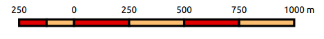
You can also change the secondary color in scale bars of the type in the picture above. Previously it was only possible to change the primary color and the secondary would always remain white.
Properties for arrows and tables have also been overhauled, as well as HTML windows. Here you can now define styles for the HTML content, which gives you the possibility to adjust the appearance to the rest of your layout. There’s also increased possibilities to define the HTML content with formulas and selections.
Finally
There’s a lot of additional changes you will not see when you just glance over the software comparing it to the current version, so the listed features above should be seen as examples of improvements that is reasonably easy to spot and appreciate.
By the way, the discussion over improvements for QGIS 2.8 has already started. Possibly we will see a change in geometry engine enabling 3D and X/Y/Z/M internally in QGIS. This will enable more geometry types and making it possible to use “curves” for instance. Ever present in the discussions is the upgrade to QT5, which may be more troublesome because of dependencies for full functionality as we’re used to.
Both of these speculated changes are major and significantly dependant on the community. Please Donate!
The post QGIS 2.6 Feature Freeze appeared first on Digital Geography.